Planning, Farmland Preservation
ORDER
Adopting Amendments to the Policies, Procedures, and By-Laws (“The Regulations”) of the Delaware Agricultural Lands Preservation Foundation.
The Delaware Agricultural Lands Preservation Foundation Policies, Procedures, and By-laws were adopted on January 1995. Proposed changes to that document were submitted to the Register of Regulations and made available for public comment from that date until June 30, 1999.
Public Meetings/Hearings:
April 1, 1999 Kent County Regional Planning Commission Meeting: Room 202, Robert O’Brien Administration Building, 414 Federal Street, Dover, DE 19901. Public Meeting - 6:30 p.m.
April 6, 1999 New Castle County Planning Board: New Castle County Council Chambers, Louis L. Redding City/County Bldg., 800 French St., Wilmington, DE 19801. Public Meeting - 7:00 p.m.
April 14, 1999 Delaware Agricultural Lands Preservation Foundation: Delaware Department of Agriculture Conference Center, 2320 S. DuPont Highway, Dover, DE 19901. Public Meeting -7:00 p.m.
April 15, 1999Sussex County Planning and Zoning Commission: Sussex County Council Chambers, County Administration Bldg., The Circle, Georgetown, DE 19947. Public Meeting -7:30 p.m.
April 19, 1999 Delaware Agricultural Lands Preservation Foundation: Middletown High School, Chorus Room, 120 Silver Lake Road, Middletown, DE 19709. Public Meeting - 7:00 p.m.
April 21, 1999 Delaware Agricultural Lands Preservation Foundation: Delaware Department of Agriculture Conference Center, 2320 S. DuPont Highway, Dover, DE 19901. Public Hearing -9:30 a.m. The hearing closed at 10:50 a.m.
POLICIES, PROCEDURES, AND BY-LAWS ADOPTED JANUARY 1995: EXHIBIT A
AMENDMENTS TO POLICIES, PROCEDURES, AND BY-LAWS - PROPOSED FEBRUARY 1999:
EXHIBIT B
SUMMARY
The major changes to the Regulations of the Delaware Agricultural Lands Preservation Foundation are the Foundation’s response to the requirements of the Fiscal Year 1999 Bond Bill which set new priorities for the Foundation to focus its efforts on areas near and adjacent to growth areas. While there are numerous “housekeeping” changes to the regulations brought about by statutory changes and experience, the sections relating to the new priorities from the Bond Bill encompass three major features:
(1) Ten points were added to the Foundation Priority Ranking System for an applicant’s parcels which are within three (3) miles of a designated Growth Area. The Foundation would use the map approved by the Governor’s Cabinet Committee for Statewide Planning Issues and proposed by the Foundation to rate this factor.
(2) A minimum of 75% of available funds will be directed for farms which are within three (3) miles of a designated Growth Area.
(3) A rebate of 20% of appraised value of the Development Rights for farms which are within three (3) miles of a designated Growth Area when selected for purchase by the Foundation. This provision echoed the Bond Bill waiver allowed on the matching requirements of the appropriation. This rebate was intended to encourage landowners close to growth areas (where opportunity costs for preservation are high) to make a competitive offer to sell their development rights to the Foundation. The proposed changes would not apply to lands where the Foundation had already purchased preservation easements, only those that are eligible for future consideration.
SUMMARY OF VERBAL AND WRITTEN TESTIMONY FROM PUBLIC HEARING
There were several comments in favor and opposed to the changes as presented. Most of the comments and concerns centered around the three Purchase of Development Rights (PDR) prioritization changes noted above.
People who stood to be both positively and negatively impacted by the proposed changes were not comfortable with the idea of shifting program policy while so many participants had joined with an understanding of current rules and procedures. Some felt that the proposed changes were unfair and discriminatory. A recurring theme was that landowners should be afforded the opportunity to withdraw from the program (which has a ten-year minimum participation agreement) if they were negatively affected by the changes.
Because of current zoning laws, many felt that the long-term protection of properties closer to growth zones would encourage development to “leapfrog” beyond the State’s investments into the more rural areas. The policies will make land protection more expensive for the Foundation and will not protect as much land as had been done under the original Regulations. The combination of the new provisions would make landowners outside of the target zone less likely to enter the program.
In each county there were concerns that changes ran somewhat counter to current planning goals within the respective counties:
In New Castle County, the State would be placing a high(er) priority for preservation in an area the County plans to serve with sewer. In Kent County, too many areas conflicted with those planned for County growth. The proposed shift in priorities, if played out, would take away the County’s ability to determine where growth and preservation should occur. In Sussex County it was felt that the changes did not reflect the goals of the County Comprehensive Plan. There were also concerns over not allowing enough room for municipalities to grow.
AMENDMENTS TO POLICIES, PROCEDURES, AND BY-LAWS AFTER HEARINGS JUNE 1999:
EXHIBIT C
Many of the comments and concerns were taken into account by the Foundation and the staff, which resulted in the following conclusions and recommendations regarding the amendments:
The financial gain recognized by a 20% rebate of the appraised value on the PDR purchase price was a clear advantage for owners in the target zone over others in the program. By removing the 20% rebate from the proposed rules, the bidding becomes more equitable amongst program participants. The 20% rebate, if implemented, could have resulted in protection of no prime farm lands (due to very competitive offers) outside the target preservation zone and imposed unfairness on landowners located in the target zones who had previously sold their development rights to the Foundation. Accordingly, it is recommended that the proposed 20% rebate be deleted.
Remove the ten (10) point bonus from the ranking so all farms can be ranked on a “level playing field” with the same 100-point criteria. The Foundation included a provision which allows for the appraisal of all properties eligible for PDR’s. In the event that appraisals on all properties occur, the ten (10) point bonus becomes rather moot and unnecessary. Accordingly, it is recommended that the ten (10) point bonus proposed be deleted.
Because the goals of the Bond Bill Committee and Cabinet Committee on State Planning Issues still have to be met, it is recommended that the Foundation spend up to (as opposed to a minimum of) 75% of the monies available in the target (priority) preservation zone and up to 25% in the non-priority preservation zone. While this creates two pools of competitive bidding, the Foundation avoids a situation where lands outside of the target zone are not protected. The measure also provides a degree of fairness to landowners outside the target zones who have been in the preservation program for many years.
It is recommended that the Amendments to the Regulations as set forth in Exhibit “C” be adopted on the basis of the evidence and information presented and the findings set forth.
POLICIES, PROCEDURES, AND BY-LAWS AS ADOPTED JUNE 1999: EXHIBIT D
are hereby adopted by this Order this 30th day of June, 1999.
Effective Date of this order shall be August 10, 1999
Delaware Agricultural Lands Preservation Foundation Board Members
Dr. Donald F. Crossan, Chairperson
Robert F. Garey, Vice Chairperson,
Kent County Representative
Jane T. Mitchell, Secretary, Grange Representative
H. Dennis Clay, Treasurer,
New Castle County Representative
John F. Tarburton, Secretary of Agriculture
Nicholas A. DiPasquale, Secretary of the
Dept. of Natural Resources & Environmental Control
Jack Markell, State Treasurer
Alden Hopkins, Farm Bureau Representative
William W. Vanderwende, Sussex County Representative
*The Delaware Lands Preservation Strategy Chart is not reproducible in the Register. Copies of the Delaware Lands Preservation Strategy Chart are available from the Department of Agriculture or the Registrar.
Delaware Agricultural Lands Preservation Foundation
Policies - Procedures - By-laws
Adopted January 17, 1995
[Revised June 30, 1999]
Table of Contents
Legislative Intent 1
Program Intent 1
Delaware’s Agricultural Lands Preservation Foundation
By-laws 2
Preamble 2
Article I: Origin of the Organization 2
Article II: Mission Statement 2
Article III: Organizational Structure 3
Article IV: Officers 4
Article V: Organizational Function 4
Article VI: Organizational Authority Granted
by Title 3, Chapter 9 of the Delaware Code 5
Article VII: Organizational Responsibilities 6
Article VIII: Parliamentary Matters 7
[Article IX: Adoption 8]
Guidelines Used for The Delaware Agricultural
Lands Preservation Program 9
Criteria for District Eligibility 9
Application Procedures 9
Application Review Procedures 10
Creation of a District 11
District Restrictions 11 12
Continuation of a District 12 13
Expansion of a District 13
Inspection of Districts 13
Dwelling Property Hardship Exceptions 14
Delaware Farmland Preservation Fund 14 16
Authority 14 16
Sources of Funding 14 16
Criteria for the Purchase Of Agricultural Lands
Preservation Easements {3 Del.C.,§904(a)(2)} 15 17
Intent 15 17
Schedule for Acquisition of Agricultural Lands
Preservation Easements 15 17
Local Matching Contributions to the Program 16 18
Eligibility Criteria for Agricultural Lands
Preservation Easements 16 19
Application Procedures 16 19
Review and Evaluation of Agricultural Lands
Preservation Easement Application 18 20
Weighting and Scoring System for Prioritizing
Agricultural Lands Preservation Easements 18 21
Lesa Score 19 21
Productivity of Current Farm Operations 19 22
Other Factors 20 22
Non-scoring Factors for Consideration 20
Appraisals 21 24
Comparable Sales Data 22 25
Agricultural Lands Preservation Easement
Value and Purchase Price 23 26
Offer of Purchase by the Foundation 23 26
The Agricultural Lands Preservation Easement Deed 25 29
Title Quality 25 30
Appendix A Application for a Preservation District 26 31
Appendix B District Agreement 27 33
Appendix C [Criteria Checklist/Staff] Report 32 38
Appendix D Time-line to Establish a District 35
Appendix E D Application for an Agricultural
Lands Preservation Easement 36
Delaware Agricultural Lands Preservation
Foundation Agricultural Preservation Easement
Application 37 42
Appendix F E Types of Farm Operations by
Value/intensity & Investment 41 47
Appendix G F Agricultural Land Preservation
Easement 42 48
Appendix H G Strategy Map Numerical Formula 45 50
[Appendix I H Adoption of the Purchase
of Agricultural Lands Preservation
Easements Order 47 52]
* The above page numbers refer to the original document and not to the Register.
LEGISLATIVE INTENT
Delaware farms and farmlands are vanishing at an alarming rate. Thirty-nine percent of the agricultural land in Delaware disappeared in the last 70 years due to commercial and population expansion. In 1920, there were 10,300 farms tilling 944,500 acres of land. In 1990, there were 2,900 farms operating and only 570,000 acres of land dedicated to the profession of farming. These figures impact all Delawareans because agriculture employs more people than any other industry in Delaware and is a leading contributor to the State's economy. If the loss of farmland continues at the current rate, then the State of Delaware will be in danger of losing its number one industry, agriculture.
On JULY 8, 1991, Governor Michael N. Castle signed House Bill 200 to amend Chapter 9, Title 3, of the Delaware Code. The legislation established a comprehensive agricultural lands preservation program to serve the long-term needs of the agricultural community and the citizens of Delaware. It is the declared policy of the State to conserve, protect and encourage improvement of agricultural lands within the State for the production of food and other agricultural products useful to the public which are grown, raised or harvested on land and water in the State of Delaware.
The Agricultural Lands Preservation Foundation was created by this legislation to accomplish this mission by establishing Agricultural Preservation Districts of viable and productive farmland and forest land. The Foundation is directed to provide economic incentives and benefits to agribusiness, purchase development rights from landowners; encourage development in areas where infrastructures exist, and promote the agricultural industry and the concept of preserving viable land for the future. [3 Del. C., §901]
PROGRAM INTENT
The Agricultural Lands Preservation Program was created as a long-term response to the depletion of valuable farmland. It is designed to provide landowners with an incentive to remain in agriculture as opposed to subdividing and selling productive farmland. The Agricultural Lands Preservation Foundation was established to develop and implement a comprehensive agricultural lands preservation program. These program guidelines represent policies and procedures adopted by the Agricultural Lands Preservation Foundation and the "Guidelines for the Delaware Agricultural Lands Preservation Program" section represents an exercise of the Foundation's regulatory responsibilities under 3 Del. C., §904(a) and (b)(21). These guidelines will govern the work of the Foundation. The program contained herein augments CHAPTER 9, TITLE 3 of the DELAWARE CODE.
Delaware’s Agricultural Lands Preservation
Foundation By-Laws
PREAMBLE
The Agricultural Lands Preservation Foundation, also referred to as the Foundation, accepts and assumes its responsibility to develop and implement a comprehensive agricultural lands preservation program to serve the long-term needs of the citizens of Delaware. In accordance with 3 Del. C., §904 (b)(20), the Foundation hereby adopts these BY-LAWS.
1. ARTICLE I: ORIGIN OF THE ORGANIZATION
On July 8, 1991, Governor Castle signed House Bill 200 which created the Agricultural Lands Preservation Foundation. This organization is established and created as an independent entity by Section 1 of Chapter 9, Title 3 of the Delaware Code.
2. ARTICLE II: MISSION STATEMENT
The Foundation's mission is to develop and implement a comprehensive agricultural lands preservation program for Delaware. Encompassed in the enabling legislation are the following goals for the Foundation:
2.1 Establish criteria for Agricultural Preservation Districts (For the purpose of this document, they will be referred to as "Districts").
2.2 Establish Districts of viable and productive farmland and forest land in accordance with the established criteria.
2.3 Develop and implement an application process that includes County Farmland Preservation Advisory Boards, County Planning and Zoning authorities, and the Foundation.
2.4 Develop a strategy map identifying the critical agricultural areas of the State, to be used as a guide for establishing Districts and purchasing preservation easements.
2.5 Establish criteria for purchasing development rights from landowners in Districts, including the prioritization of purchases in those areas located near and adjacent to designated growth zones.
2.6 Purchase development rights of landowners in a District in accordance with established criteria.
2.7 Encourage development in areas where infrastructures exist.
2.8 Provide economic incentives and benefits to encourage landowners who preserve their land.
2.9 Promote and encourage the preservation and support of agriculture as an industry and a valued occupation.
2.10 Work closely with the Department of Agriculture, Department of Natural Resources and Environmental Control, other state agencies, and private organizations concerned with promoting Delaware's agricultural sector and protecting open space.
2.11 Work with county and local governments to encourage farmland preservation in land use planning and zoning activities.
3. ARTICLE III: ORGANIZATIONAL STRUCTURE
3.1 The Foundation is comprised of nine (9) Trustees, all appointed by the Governor. Each Trustee must be a resident of Delaware and qualified to vote in the State of Delaware.
3.2 The Chairperson of the Foundation, will serve at the pleasure of the Governor and will be confirmed by the Senate.
3.3 The Secretary of the Department of Agriculture or designee, the Secretary of the Department of Natural Resources or designee, and the State Treasurer or designee will serve an indefinite term.
3.4 Each county will have a representative who is actively engaged in agribusiness to serve on the Foundation for an initial period of three (3) years.
3.5 For the four (4) Trustees appointed to the positions indicated in sections 3.2 and 3.4 above, Trustees registered in either major political party shall not exceed the other major political party by more than one (1).
3.6 One (1) representative from the Delaware Farm Bureau, selected from a list of three (3) nominees, will serve for an initial term of two (2) years.
3.7 One (1) representative from the Delaware State Grange, selected from a list of three (3) nominees, will serve for an initial term of two (2) years.
3.8 The Governor will appoint an interim Trustee in the event of a death, permanent disability, resignation, or failure to perform duties of a Trustee. The replacement will serve the unexpired term of the departing Trustee. The Chairperson's replacement must be confirmed by the Senate if his/her residual term exceeds six (6) months. [3 Del. C., §903]
4. ARTICLE IV: OFFICERS
4.1 Other officers of the Foundation besides the Chairperson shall include a Vice Chairperson, a Secretary and a Treasurer.
4.2 The Chairperson shall preside and maintain order at all meetings of the Foundation.
4.3 The Vice Chairperson shall act for the Chairperson in his/her absence.
4.4 The Secretary shall be responsible for recording the minutes of the Foundation meetings.
4.5 The Treasurer shall be responsible for maintaining records of all receipts and disbursements and shall submit a monthly financial report to the Foundation.
5. ARTICLE V: ORGANIZATIONAL FUNCTION
5.1 The Foundation will meet at least quarterly; executive meetings or an emergency meeting may be called by the Chairperson.
5.2 All Foundation meetings, except for executive sessions, are open to the public and advance notice will be given in accordance with applicable statutory requirements. Public hearings shall be conducted in accordance with the requirements of 3 Del. C., §928.
5.3 Minutes of every meeting will be recorded and available to the public. An agenda will be sent to each Trustee no less than seven (7) days before the next scheduled meeting, if feasible, provided however that the agenda may be modified as necessary in advance of a meeting in which case the maximum period of notice will be provided.
5.4 Five (5) Trustees will constitute a quorum for conducting business of the Foundation.
5.5 A majority vote of members constituting a quorum is required for action on any matter before the Foundation.
5.6 A Trustee is not entitled to vote on any matter before the Foundation if such Trustee knowingly has a financial interest in the outcome of such matter. The Trustee will inform the Chairperson of his/her conflict of interest and will be recorded in the minutes of the meeting.
5.7 The Foundation may adopt policies and guidelines as necessary for the proper conduct of its work.
5.8 The BY-LAWS will be reviewed periodically by the Trustees.
5.9 Amendments to these BY-LAWS and policies will be introduced with prior notice to the Trustees.
5.10 An Annual Report will be prepared summarizing proceedings and activities for the annual period ending September 30. The Annual Report shall be submitted prior to January 1 following the close of the reporting period. [3 Del. C., §903, §904]
6. ARTICLE VI: ORGANIZATIONAL AUTHORITY GRANTED BY TITLE 3, CHAPTER 9 OF THE DELAWARE CODE
6.1 To purchase, sell, manage, lease, or rent real and personal property for use of the Foundation.
6.2 To seek, obtain, and utilize federal and private funding.
6.3 To accept gifts, grants or loans of funds, property or service from any source, private or public.
6.4 To receive funds from the sale of general bonds, revenue bonds or other obligations of the State or under the name of the Foundation.
6.5 To establish a Delaware Farmland Preservation Fund.
6.6 To recover reasonable costs for service provided and to collect rollback taxes from real estate transactions.
6.7 To adopt procedural rules to govern how internal affairs of the Foundation are conducted.
6.8 To select an Executive Director, who shall be chief executive officer of the staff to the Foundation.
6.9 To employ a staff subject to the availability of funding.
6.10 To retain by contract auditors, accountants, appraisers, legal counsel, surveyors, private consultants, financial advisors, or other contractual services required by the Foundation.
6.11 To delegate to one (1) of its members, its Executive Director or its agent, such powers and duties necessary to conduct authorized business on behalf of the Foundation.
6.12 To adopt, after notice and public hearing, policies and guidelines to fulfill the Foundation's responsibilities.
6.13 To undertake such other activities authorized by the Foundation's enabling legislation and the amendments thereto. [3 Del. C., §904]
7. ARTICLE VII: ORGANIZATIONAL RESPONSIBILITIES
7.1 To develop and implement, after public hearing, a statewide agricultural lands preservation strategy which specifically identifies the areas in which viable, productive agriculture lands are located and which are considered most vital for permanent preservation, and to identify growth zones, and those areas located near and adjacent to designated growth zones to be given priority for acquisition of preservation easements.
7.2 To adopt, after public hearing, criteria for establishing and maintaining Agricultural Preservation Districts.
7.3 To adopt, after public hearing, criteria for establishing and maintaining a program to purchase development rights.
7.4 To establish a program of cooperation and coordination with the counties, municipalities, and other governmental bodies of Delaware and with private non-profit or public organizations to assist in the statewide preservation of agricultural land.
7.5 To monitor and enforce the requirements, restrictions and policies developed by the Foundation.
7.7 To administer, operate, and supervise, the Delaware Farmland Preservation Fund.
7.8 To engage the services of an independent certified public accountant to conduct an annual audit of the Foundation's accounts at the end of each fiscal year.
7.9 To develop and establish a program of education and promotion of agricultural lands preservation.
7.10 To engage in such other activities designed to promote an effective program. [3 Del. C., §904]
8. ARTICLE VIII: PARLIAMENTARY MATTERS
8.1 In all matters not covered in 3 Del. C., Chapter 9 or these By-Laws, Roberts Rules of Order shall apply.
[9. ARTICLE IX: ADOPTION
These BY-LAWS have been adopted at a regular Foundation meeting and are effective as of 1992. 1999, and supercede all prior By-Laws adopted by the Foundation.
__________________________________ Date:______________________
Dr. Donald F. Crossan, Chairperson
Date:
Robert F. Garey, Vice Chairperson
Kent County Representative
Date:
Jane T. Mitchell, Secretary
Grange Representative
Date:
Dennis H. Clay, Treasurer
New Castle County Representative
Date:
John F. Tarburton
Secretary of Agriculture
Date:
Mary L. McKenzie
Acting Secretary of the Dept. of Natural Resources & Environmental Control
Date:
Jack Markell
State Treasurer
Date:
Alden Hopkins
Farm Bureau Representative]
GUIDELINES USED FOR THE DELAWARE AGRICULTURAL LANDS PRESERVATION PROGRAM
The Foundation is granted authority to establish criteria for Agricultural Preservation Districts (hereinafter referred to as "Districts") and the purchase of preservation easements. [3 Del. C. §904]
1. CRITERIA FOR DISTRICT ELIGIBILITY
1.1 In order to qualify for the Agricultural Lands Preservation Program, the lands proposed as a Agricultural Preservation District in the application must meet the following criteria:
a) owner(s) shall hold fee simple title to all land to be placed in a District;
b) must constitute at least 200 acres of contiguous farmland or lesser acreage if the farmlands are located within three (3) miles of an established District;
c)shall be zoned for agricultural purposes and shall not be subject to any major subdivision plan;
d) applicant(s) including all fee simple title holders, must sign a written agreement committing to District restrictions set forth in this Section and 3 Del. C., §909 and other adopted requirements.
e) must be viable and productive agricultural land and meet the minimum County Land Evaluation and Site Assessment (LESA) scoring requirements for eligibility as established by the Foundation.
[3 Del. C., §908 (a)(3)]
f) must include all of the eligible real property located in the tax parcel or tax parcels subject to application.
1.2 For the purposes stated in this chapter, the phrase "viable and productive agricultural land" is defined as land that qualifies under provisions of the Farmland Assessment Act. [9 Del. C., §8329 - 8333]
1.3 The minimum LESA score for an eligible District or Expansion shall be 170 points out of a possible 300 points for each county in the State as computed under the currently approved LESA program of the Delaware Department of Agriculture.
2. APPLICATION PROCEDURES
2.1 The Foundation will provide application forms (Appendix A) on which applicants who volunteer to place their lands into an Agricultural Preservation District will provide the following information:
1. name of petitioner(s)
2. mailing address(es)
3. telephone number(s)
4. property location
a. county
b. community name
5. deed or property description
6. area - total acreage of:
a. cropland
b. woodland
c. pasture
d. aquaculture
e. tidal wetlands
f. farm structures
g. residence/buildings
h. other
7. land use/zoning designation or designations
8. easements/rights-of-way (identify, if any)
9. mortgages/liens (identify, if any)
a. mortgagee or lien holder's name or names
b. date of mortgages or liens
10. number of dwelling units
11. soil and water conservation plan (if any)
12. proof of eligibility under the Farmland Assessment Act
13. evidence of historical significances (if any)
14. information regarding the occupancy of dwelling units on the property
2.2 The Foundation shall provide assistance to potential applicants in completing application forms when requested [3 Del. C., §907 (a)]
2.3 Foundation staff shall may conduct on-site inspections and/or phone interviews with the applicants to acquire data necessary to perform LESA analyses and write a staff report.
2.4 In conjunction with the application, all fee simple owners shall sign a District Agreement (Appendix B) which serves as a declaration in recordable form of acknowledgment of the policies and restrictions that must be followed, and all benefits realized in a District.
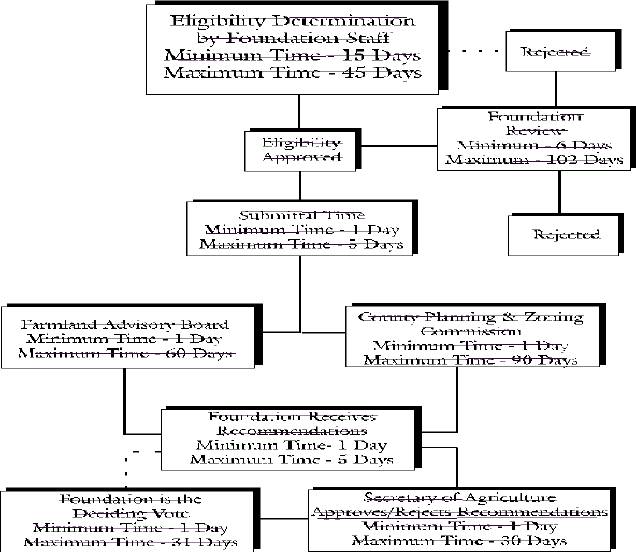
3. APPLICATION REVIEW PROCEDURES
The Foundation has the authority to approve applications, establishing Agricultural Preservation Districts and purchasing preservation easements. [3 Del. C., §904]
3.1 The Foundation staff will review applications and determine whether or not the minimum eligibility requirements under Section 1.1 have been met.
3.2 If the minimum eligibility requirements have not been met, then the applicant will be notified by letter from the Foundation indicating that the application does not qualify for further review, and the reasons for ineligibility.
3.3 If an applicant excludes a portion of property otherwise includable in a proposed District, then the Foundation reserves the right to shall deny the application.
3.4 Subject to Section 3.3 above, if the lands proposed as a District in the application meet minimum eligibility criteria, then the Foundation staff will submit to the Foundation, the County Farmland Preservation Advisory Board and the County Planning and Zoning Authority, applications and criteria checklists describing and summarizing the criteria as established in this chapter (see Appendix C).
3.5 If the applicant disagrees with the staff evaluation of the proposed District, then the applicant may contact the Foundation staff to discuss the application review. Foundation staff will meet with the landowner to discuss the review within thirty (30) days from receiving such telephone call or letter.
3.6 If the issue is not resolved to the applicant's satisfaction, he/she may request an administrative review with the Foundation by submitting a letter to the Foundation within fourteen days (14) of the applicant's last meeting with Foundation staff.
3.7 This letter must include reasons and documentation to justify the applicant's claim(s).
3.8 Within seven (7) working days from the receipt of the landowner's letter, the Foundation will schedule a meeting and notify the applicant by certified letter of the date, time, and place of the meeting, at least seven (7) days in advance.
3.9 At the administrative review meeting, the applicant(s) shall present information or documentation as to how the proposed District satisfies the eligibility criteria.
3.10 The Foundation will render a decision within thirty (30) days from the administrative review meeting and notify the applicant in writing of its decision.
4. CREATION OF A DISTRICT
4.1 To establish an Agricultural Preservation District, the application must be approved by two out of three of the entities listed under section 3.4 of these guidelines. [3 Del. C., §907 (c)]
4.2 After review by the Foundation, the application is subject to a review period of thirty (30) days in which the Secretary of Agriculture may reject the application. The application is officially approved at the end of the review period, if it is not rejected by the Secretary of Agriculture. [3 Del. C., §919]
4.3 The property legally becomes a District when the applicant and Foundation Chairperson (or designee) have signed the District Agreement and no rejection has been exercised by the Secretary of Agriculture, or the Secretary of Agriculture has specifically approved the application.
4.4 Copies of the District Agreement shall be filed with the County Planning and Zoning and Tax Assessor's Offices and recorded in the Office of the Recorder of Deeds. The Foundation shall require from these Offices proof of recording and/or receipt of the District Agreement.
4.5 Applicants shall receive The Foundation shall endeavor to provide written notification of the date of establishment of the Agricultural Preservation District and shall receive provide a copy of the District Agreement to the applicant, however, the failure of the Foundation to satisfy any formality following execution of a District Agreement shall not affect the validity of the District Agreement.
5. DISTRICT RESTRICTIONS
5.1 Any rezoning or major subdivision of real property included in an Agricultural Preservation District is prohibited. [3 Del. C., §909 (a)(1)]
5.2 The submission of applications or preliminary rezoning or subdivision plans for any property within an Agricultural Preservation District to a county or municipality shall be considered evidence of the intent to rezone or subdivide and is prohibited.
5.3 All activities on the property shall be limited to "agricultural and related uses." l [3 Del. C., §909 (a)(2)]
5.4 For the purposes of this chapter these guidelines, the phrase 'agricultural and related uses' shall be defined as, all forms of farming including but not limited to, agriculture, horticulture, forestry, aquaculture, or silviculture as defined in the Farmland Assessment Act of 1968 [9 Del. C., Chapter 83] and 3 Del. C., §403 or by the National Agricultural Statistics Service.
5.5 Excavation or filling, borrow pits, extraction, processing and removal of sand, gravel, loam, rock or other minerals is prohibited unless such action is currently required by or ancillary to any preparation for, or operation of any activities including, but not limited to: aquaculture, farm ponds, cranberry operations, manure handling facilities, and other activities directly related to agricultural production.
5.6 Activities that would be detrimental to drainage, flood control, water conservation, erosion control or soil conservation are prohibited;
5.7 Any other activity that might negatively affect the continued agricultural use of the land is prohibited.
5.8 The term "usable land owned in the district" [3 Del. C., §909 (a)(2)], shall be defined as any land meeting the requirements for agricultural, horticultural or forest land in the Farmland Assessment Act of 1968 [9 Del. C., Chapter 83] and 3 Del. C., §403 or criteria for farm definition as established by the National Agricultural Statistics Service.
5.9 The District Agreement and District requirements and benefits shall be binding on the heirs, successors and assigns of property owners of lands within a District. A property owner in a District shall provide written notice to a successor or assign in advance of the date of transfer of the property that the property is subject to District restrictions. The party taking title shall execute a written acknowledgement that the transferred property is subject to District restrictions document as required by 3 Del. C.§909(a) (2) (iii) acknowledging the acreage allowed for dwelling housing and the restrictions which apply to the property.
5.10 Under 3 Del. C., §909 (a)(3), all restrictions shall be covenants which run with and bind the lands in the District for a minimum of ten (10) years, beginning when the District Agreement takes effect as specified in section 4.3 of these guidelines. the District Agreement.
6. CONTINUATION OF A DISTRICT
6.1 All properties are to remain in an Agricultural Preservation District for at least ten (10) years, subject to the allowance of hardship exceptions for exclusion of dwelling pursuant to 3 Del. C.§909(a) (2) (ii) and Section 9 of these guidelines.
6.2 If a landowner wishes to withdraw from, or terminate a District, then the Foundation must receive a written notice of intent to withdraw no less than six (6) months prior to the ten (10) year anniversary date of initial establishment of the District. [3 Del. C., §909 (b)]
6.3 If the Foundation does not receive a written notification of the landowner's intent to withdraw from the District six (6) months prior to the ten (10) year anniversary date of that District, then the land shall remain in the District, unless notice of intent to withdraw shall be given within six months of the end of each additional five-year period.
7. EXPANSION OF A DISTRICT
7.1 An Agricultural Preservation District can be expanded for the purpose of preserving additional lands. Lands added to a District may be under 200 acres. [3 Del. C., §907 (d)]
7.2 Land which is less than 200 usable acres, yet meets the other criteria established by the Foundation is eligible to be an expansion of an Agricultural Preservation District if it is within one mile three (3) miles of any portion of an established Agricultural Preservation District. [3 Del. C., §907 (a)]
7.3 The Foundation will re-evaluate Districts at the time of removal of any lands. If any remaining parcels of land subsequently fail to meet the minimum requirements for a District as set forth in 3 Del. C., §908, then the Foundation, after notice to the owner or owners, may terminate the District Agreement(s) upon expiration.
8. INSPECTION OF DISTRICTS
The Foundation has the authority to enter upon lands as may be necessary to perform surveys, appraisals, and investigations to accomplish its mission; consistent with applicable statutes. [3 Del. C., §904 (b)(14)]
8.1 The Foundation or its designee reserves the right to inspect restricted land and enforce agreements on its own behalf.
8.2 If any violations of the terms and the conditions of the District Agreement occur, the Foundation may institute proceedings in the appropriate court to enforce the terms and seek appropriate relief. [3 Del. C., §920 (a)]
9. DWELLING PROPERTY HARDSHIP EXCEPTIONS
In accordance with 3 Del. C. §909(a) (2) (ii), the legal or equitable owners of real property subject to a District Agreement or Preservation Easement are entitled to apply to the Foundation for a hardship exception allowing for the transfer of dwelling property to parties who are not otherwise entitled to residential use of the dwelling property under the District Agreement or Preservation Easement, subject to the provisions of [3 Del. C.] §909(a) (2) (ii) and the following requirements.
9.1 An applicant for a hardship exception shall submit the following information in writing to the Foundation:
1. name and property interest of the applicant in the dwelling property
2. acreage of the dwelling property subject to application
3. date on which the District was established
4. number of dwellings and acreage of residential use currently on the property in the District
5. the nature of the hardship condition and reasons justifying the granting of a hardship exception
6. the extent to which the hardship condition is unavoidable
9.2 The Foundation shall consider hardship conditions involving the following circumstances:
1. the sale or transfer of the dwelling property compelled by foreclosure, court order, or marital property division agreement.
2. the sale or transfer of the dwelling property compelled by job transfer.
3. the sale or transfer of the dwelling property compelled by health conditions.
4. the sale or transfer of the dwelling property required to avoid insolvency or bankruptcy.
5. other circumstances of an unusual and extraordinary nature which pose a practical hardship to continued ownership of the dwelling property and which are unavoidable.
9.3 Hardship exceptions will not be granted when no real hardship exists and the primary consequence of the sale or transfer of the dwelling property is financial gain.
9.4 The applicant shall bear the burden of establishing the existence of hardship circumstances, and shall provide to the Foundation documentation in support of the application, and any documentation requested by the Foundation, provided however, that documentation involving privileged information may be submitted on a confidential basis.
9.5 The Foundation may require the applicant for a hardship exception to appear before the Foundation Board to present the application, and an applicant shall be entitled to appear before the Board to make a presentation by submitting a written request to the Foundation.
9.6 The granting of a hardship exception by the Foundation shall be subject to the following conditions:
1. the dwelling property following transfer shall be used only for residential purposes.
2. the transferred property shall not qualify for District benefits or benefits of Preservation Easements.
3. if the transferred property is subject to a Preservation Easement prior to transfer, payment shall be made to the Foundation in an amount equal to twenty-five (25) percent of the current fair market value of the land subject to transfer.
4. the transferee shall execute a Declaration in recordable form as prescribed by the Foundation which includes the acreage allowed for dwelling housing and the restrictions which apply to the real property.
5. the Foundation may require the transferor to execute a Declaration in recordable form as prescribed by the Foundation to evidence the status of allowable dwelling housing property on lands retained by the transferor which are in the District or subject to a Preservation Easement.
6. such other terms and conditions considered necessary by Foundation to address the nature of the hardship condition.
DELAWARE FARMLAND PRESERVATION FUND
9. INTENT
The Delaware Farmland Preservation Fund, hereinafter referred to as the "Fund" was enacted under 3 Del. C., §905 for the exclusive application by the Foundation to achieve the desired goals of preserving viable agricultural lands and conducting the business of the Foundation.
10. AUTHORITY
10.1 The Foundation Trustees shall manage and administer the Fund according to the requirements as stated in 3 Del. C., §905. A Trustee shall be elected as Foundation Treasurer to monitor and supervise the Fund.
10.2 The Foundation has the authority to hire an Executive Director and any other staff necessary to accomplish its mission. Salaries for these positions and retention of consultants and other professionals will be paid from the Fund.
10.3 The Foundation members, by a majority vote, can purchase all the necessary materials, equipment, and services to perform its mission. All necessary expenses incurred by the Trustees to enable the performance of their duties are paid from the Fund.
10.4 The Foundation has the authority to establish accounts at any bank or financial institution, purchase certificates of deposit or other appropriate investment instruments.
10.5 Any two officers, or one officer and a designated staff person, are authorized to sign checks and drafts against any accounts established by the Foundation, providing such expenditures have been budgeted or specifically approved by the Board.
11. SOURCES OF FUNDING
11.1 The Foundation may accept donations, property, or development rights as gifts and monetary gifts from any source, public or private.
11.2 Monies not needed on a current basis by the Foundation will be invested with the approval of the Board of Trustees.
11.3 The Fund is subject to an annual audit to be prepared by an independent, certified public accountant. The findings of all audits shall appear in the Foundation's Annual Report.
11.4 The Foundation shall manage the monies appropriated to it by the General Assembly in accordance with the terms of the appropriations.
CRITERIA FOR THE PURCHASE OF AGRICULTURAL LANDS PRESERVATION EASEMENTS {3 DEL.C., §904(a)(2)}
12. INTENT
12.1 The intent of this section is to provide a framework for the acquisition of Agricultural Lands Preservation Easements (hereinafter referred to as "Preservation Easements") to protect in perpetuity those lands of the state most suitable for long-term agricultural production, and to preserve a sufficient critical mass of agricultural land to insure the economic viability of the agriculture industry, and to protect farmland from development in those areas located near and adjacent to designated growth zones.
12.2 The Foundation will place greatest emphasis on acquiring Preservation Easements in areas where significant agricultural acreage can be maintained for long-term agricultural production and prioritize acquisitions in areas located near and adjacent to designated growth zones.
12.3 Based on the long range goal of preserving a sufficient critical mass, the Foundation will give primary consideration to the Agricultural Lands Preservation Strategy Map for the State of Delaware {3 Del.C., §904(a)(2)} in the acquisition of Preservation Easements.
12.4 In the criteria established for the prioritization of Preservation Easements, the Foundation will also give weight to the Land Evaluation and Site Assessment (LESA) score for the subject parcel, and the eligibility criteria used in the establishment of agricultural districts, and factors designed to prioritize acquisitions in areas located near and adjacent to designated growth zones.
13. SCHEDULE FOR ACQUISITION OF AGRICULTURAL LANDS PRESERVATION EASEMENTS
13.1 Recognizing that voluntary applications by agricultural preservation district landowners may exceed available funds for the procurement of Preservation Easements, it is necessary to establish a procedure for pooling, reviewing, prioritizing, and funding applications for permanent Preservation Easements.
13.2 Application and funding cycles will take place in six month intervals, starting at the beginning of the Foundation's fiscal year, October 1 on schedules established by the Foundation.
13.3l Applications for the purchase of Preservation Easements received between October 1 and March 31 in each fiscal year cycle will be pooled together for review during the period April 1 through June 30, and for funding decisions to be made on these applications during the period July 1 through September 30. in Rounds of Purchases shall be subject to deadlines established by the Foundation.
13.4 Funding decisions pertaining to applications received between October 1 and March 31 will be announced during the last ten days of the Foundation's fiscal year (September 21-30). For each Round of Preservation Easement Purchases the Foundation shall rank the applications in the Round in accordance with the criteria set forth in Section 13. Following the ranking the Foundation shall establish a cut-off score, and arrange for the appraisal of the Preservation Easement value of those properties at or above the cut-off score.
13.5 Applications received between April 1 and September 30 of each fiscal year will be pooled together for review during the period October 1 through December 31, and for funding decisions to be made on these applications during the period January 1 through March 31. Upon completion, the appraisals shall be provided to the landowners, and procedures set forth in Section 23 involving offers for the sale of preservation easements shall be initiated.
13.6 Funding decisions pertaining to applications received between April 1 and September 30 will be announced during the last ten days of March (March 22-31). After receipt of offers for the sale of preservation easements, the Foundation shall review the offers and announce the selections in accordance with the provisions of Section 23.
13.7 The Foundation is under no obligation to purchase a permanent Preservation Easement which is offered for sale. Following the selection of properties for acquisition of Preservation Easements, the Foundation shall arrange for surveys of the properties to be conducted, and proceed to settlement under the terms of the Option Agreements, subject to the availability of funding and satisfaction of regulatory, financial or other restrictions or limitations.
13.8 The Foundation is under no obligation to purchase a Preservation Easement which is offered for sale. 3 Del.C., §913.
14. LOCAL MATCHING CONTRIBUTIONS TO THE PROGRAM
14.1 The Foundation may establish a reserve of available funds for the matching of federal, county, state, or local, or private funds for the preservation of farmland.
15. ELIGIBILITY CRITERIA FOR AGRICULTURAL LANDS PRESERVATION EASEMENTS
The criteria for eligibility of acquisition of a Preservation Easement shall be the same as the criteria for district eligibility. In addition, offered preservation easement lands shall be in an established district and in compliance with district requirements to be eligible.
16. APPLICATION PROCEDURES
16.1 A separate application shall be required for each farmland tract (operating farm unit) offered for Preservation Easement purchase. The application shall consist of a completed application form, location maps, a soils report and a crop report The Foundation shall not be obligated to process any incomplete application.
16.2 The Foundation shall develop, and make available to landowners or other interested parties, an application form which requires the following information (See Appendix E):
1. Name, address, telephone number and signature of the owner of the farmland tract.
2. County, municipality or hundred, and Agricultural Preservation District in which the farmland tract is located.
3. Total acreage of the farmland tract and the number of acres of that tract proposed for Preservation Easement purchase.
4. Street/Road location of the farm, and directions from the nearest State route.
5. Deed reference - book, volume and page.
6. County tax map records, including tax parcel number, or account number of each parcel.
7. If a conservation plan has been approved by the County Conservation District, specify the date of the plan.
8. Name, address and telephone number of the person to be contacted to view the farmland tract.
9. Declaration of assurance that the applicant has good title to the premises, free of encumbrances such as liens, mortgages, options, rights of others in extraction or mineral rights, land use restrictions, adverse ownership interest, and other encumbrances which would adversely impact the Preservation Easement interest in the farmland tract, or that any such encumbrances would be subordinate to the Preservation Easement to be conveyed to the Foundation.
16.3 The applicant shall provide the following information on the application:
1. Major assets and investments related to agricultural production such as buildings, packing equipment, dairy equipment, irrigation/water supply, etc.
2. Use of the land for the most recent crop year.
16.4 The applicant shall provide information on the farmland tract for the highest three crop production years out of the last five crop years on crops where comparable statistics are available from the Delaware Agricultural Statistics Service (DASS) on the Crop Production/Livestock Production form (See Appendix E).
16.5 The applicant shall provide a livestock report for the farmland tract for the most recent calendar year for which comparable statistics are available from the Delaware Agricultural Statistics Service (DASS) on the Crop Production/Livestock Production form (See Appendix E).
16.6 If the applicant grows crops or produces livestock that are of a type not reported by DASS, the Foundation applicant shall obtain provide two years of production data from the applicant to the Foundation.
17. REVIEW AND EVALUATION OF AGRICULTURAL LANDS PRESERVATION EASEMENT APPLICATION
17.1 Application periods shall be October 1 - March 31, and April 1 - September 30.
17.2 1 The Foundation shall review the application to determine if it is complete and meets the minimum criteria set forth in Section 15.
17.3 2 If the application is complete and the minimum criteria are met, an agent or member a representative of the Foundation Board of Trustees shall view the farmland tract and discuss the Preservation Easement program with the applicant.
17.4 3 The Foundation shall for each Round of Preservation Easement Purchases evaluate applications which meet the minimum criteria during the two review periods; April 1 - June 30, and October 1 - December 31 of each year, and rank them according to the Foundation's weighting system for prioritizing Preservation Easements. The Foundation shall then determine whether to appraise the farmland tract. and rank the applications in accordance with the criteria of Section 18. [Notwithstanding the ranking procedure set forth in Section 18, the Foundation shall be entitled to have all eligible properties appraised and considered for purchase of Preservation Easements pursuant to Section 22.]
18. WEIGHTING AND SCORING SYSTEM FOR PRIORITIZING RANKING CRITERIA FOR AGRICULTURAL LANDS PRESERVATION EASEMENTS APPLICATIONS
18.1 A guidance weighting system for ranking Preservation Easement applications is established to assist the Foundation in reaching a final decision.
18.2 Four Five [Four] categories will be utilized to initially rank the Preservation Easement applications during the Foundation's review periods with a maximum score of 100 points, [with 10 points added to establish a priority for ranking applications for farms near or adjacent to designated growth zones (Priority Preservation Areas). ]
18.3 Agricultural Lands Preservation Strategy Map - 50 Points.
In order to follow a rational, statewide plan for the acquisition of development rights on agricultural lands, the Foundation will give weight to applications for sale of Preservation Easements according to location on the Agricultural Lands Preservation Strategy Map. Scoring will be based on location relative to preservation categories on the map:
Class I = 50 Points
Class II = 40 Points
Class III = 25 Points
Class IV = 15 Points
Class V = 0 Points
Land will be categorized according to which class comprises the majority of the active cropland on the farm. Farms within two or more classes may shall be placed in the predominant class.
18.4 LESA Score - 20 Points.
Weight will be given to the LESA scoring on parcels being submitted for the purchase of permanent Preservation Easements. Using the highest LESA score for an Agricultural Preservation District within the county as 100%, and 170 points as 0%, then:
76 greater than 75-100% = 20 Points
51 greater than 50-75% = 15 Points
26 greater than 25-50% = 10 Points
0-25% = 0 Points
Farms with tidal wetlands and other non-productive lands will receive a LESA score based on the cropland and forest land proposed for subject to Preservation Easement acquisition by the Foundation.
18.5 Productivity of current farm operations - 15 Points.
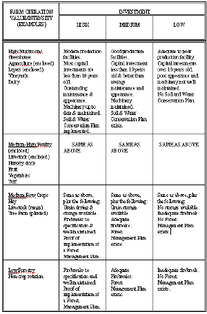
Weight will be given to the current level of productivity exhibited on the land where a Preservation Easement is offered for sale. The score is based on the type of farming being pursued, the value of investments in agriculture and the recent, proven yields of the operation.
Investment: High (upper 1/3 for type of operation) = 4 points
See Appendix F Medium (middle 1/3 for type of operation = 2 points
Low (lower 1/3 for type of operation) = 0 points
Management: Excellent = 4 points
Average = 2 points
Low = 0 points
Past Yields: High ( greater than 110% or more
of state avg.) = 4 points
Medium-High ( greater than
90% - 109 110 % of state avg.) = 3 points
Medium ( greater than
70% to 89 90 % of state avg.) = 2 points
Low (less than less than or equal to
70% of state avg.) = 0 points
Farms reporting more than one crop will receive points based on the average of points computed for each crop.
Type of High value/intensity = 3 points
Of operation: Medium-High value/intensity = 2 points
See Appendix F Medium value/intensity = 1 point
Low value/intensity = 0 points
18.6 Other factors - 15 Points.
Other criteria for eligibility used in the determination of areas to be included in the Agricultural Preservation District program will be taken into account in the decision to procure a Preservation Easement. Scores will be based on the consideration of factors specified in 3 Del. C., §908(b), relative to the Preservation Easement application.
1. The extent to which long-term preservation of the farmland and forestland is consistent with land use plans adopted at the state and or county levels.
2. The permanent protection of farmland that is near or adjacent to protected open space. The subject property is contiguous to protected open space.
3. The impact that the procurement of the Preservation Easement would have on the expansion of existing agricultural districts and the purchase of Preservation Easements on other lands in the future. The subject property is contiguous to existing agricultural districts or permanently protected farmland.
4. The socio-economic benefits derived from the long-term preservation of the agricultural land, and the history of the surrounding area and the role that it has played in Delaware agriculture. The extent to which the subject property provides documented historic, cultural, archeological, or socio-economic benefits for Delaware agriculture.
5. The potential of a Preservation Easement in this area for reducing development pressures on adjacent and nearby farmlands. The potential of a Preservation Easement in this area for reducing development pressures on adjacent and nearby farmlands and is officially documented as a high priority for preservation by another state agency or a county.
6. Lands that have implemented resource protection measures as approved by the Delaware Department of Natural Resources and Environmental Control.
An application will receive the following scores:
4 or more factors present = 15 points
3 " " = 10 points
2 " " = 6 points
1 " " = 3 points
0 " " = 0 points
[18.7 Priority Preservation Areas - 10 Points
For applications for properties which are located in, or which border in part, any Priority Preservation Area as shown on the Priority Preservation Area Map adopted by the Foundation, an additional ten (10) points shall be added to the ranking score for the application.]
19. NON-SCORING FACTORS FOR CONSIDERATION
The Foundation may consider the following additional factors beyond the weighting and scoring system and minimum criteria on an application which may affect the decision to purchase a Preservation Easement.
19.1 Discount to Appraisal - A discounted sale price of a Preservation Easement versus the appraised value of the Preservation Easement will be considered after the ranking of applications with appraisals.
19.2 Availability of Other Funding Sources - The availability of additional funding from private or public sources to assist in the purchase of a Preservation Easement shall be considered.
20.19. APPRAISALS [3 Del. C., §916]
20.1 19.1l An offer to purchase a Preservation Easement shall be based upon one or more appraisal reports which estimate the full market value of the land under its agricultural zoning designation and the agriculture-only value of the farmland tract.
20.219.2 An appraisal to the extent possible shall be based primarily on an analysis of comparable sales.
20.319.3 The value of buildings or other improvements on the farmland tract may be considered in determining the Preservation Easement value. The value of the buildings or other improvements shall appear separately in appraisal report. Excluded from the value of the Preservation Easement shall be the value of the one (1) acre of land for each dwelling structure on the property.
20.4 19.4 The appraiser shall be:
1. An independent, licensed real estate appraiser who is qualified to appraise a property for easement purchase. An appraiser shall be selected on the basis of experience, expertise and professional designation, and
2. A member of an organization which subscribes to the "Uniform Standards of Professional Appraisal Practice" published by the Appraisal Standards Board of the Appraisal Foundation, and shall follow their ethical and professional standards.
20.5 19.5 The appraiser shall supply a narrative report which contains the following information and is in the following format:
1) Introduction
a. Professional qualifications of the appraiser
b. Letter of transmittal or appraiser certificate
c. Table of contents
d. Summary of salient facts and conclusions
e. Purpose of the appraisal
f. Easement value definition as provided in 3 Del. C. §916(a).
2) Description of property
a. Area or neighborhood description
b. Description of appraised property
i. Legal description
ii. Property data and zoning
iii. Description of improvements
iv. Photos and sketches (if available) of subject property
v. Tax map of subject property. In instances where the county does not have tax maps available, the sketch map required under vi below shall include the boundary lines and acreage of properties adjoining the subject property and the names of all adjoining property owners
vi. Location map
[vii. Soils map]
ix. vii. Development constraints. The appraiser shall report whether the farmland tract has public or private land use restrictions, is within a flood plain, or has other physical attributes which limit its developmental capability
3) Analyses and conclusions
a. Analysis of highest and best development use
b. Full market valuation
i. Comparable sales data
ii. Adjustment grid
iii. Location map of comparable sales
iv. Market value estimate
c. Agriculture-only valuation
i. Comparable sales data or value based on income capitalization
ii. Location map of comparable sales (as applicable)
iii. Agriculture-only value estimate
d. Value of Improvements
e. d. Agricultural Lands Preservation Easement value
20.6 19.6 The appraiser shall provide at least one original and four three copies of each report to the Foundation. The original of each report and all copies shall be bound with rigid covers.
21. 20. COMPARABLE SALES DATA
The appraiser shall supply information concerning comparable sales as follows:
1) At least four comparable sales shall be used for an appraisal. If the appraiser cannot obtain sufficient comparable sales data within the same general area as the subject farmland tract, the appraiser may use comparable sales from other areas within the county, state or outside the state, after consultation with the Foundation. The use of comparable sales which require adjustment of 50% or more is permitted only with the approval of the Foundation.
2) Pertinent data for each comparable sale used in the preparation of the appraisal shall be stated in the appraisal report, including date of sale, purchase price, road frontage in feet, soil series, an estimate of the range of slope and other relevant information. The appraisal shall include an analysis comparing the pertinent data for each comparable sale to the subject farmland tract.
3) The location of each comparable sale used in the appraisal report shall be shown accurately on the comparable sales map and sufficiently identified and described so as to be located easily.
4) For comparable sales used to estimate the agriculture-only value, the appraiser may use sales of land that are confined to agricultural use because of legal restrictions or physical impairments that make the land valuable only for agricultural use. Data may also be gathered from farm real estate markets where farms have no apparent developmental value.
5) If comparable sales data is not available for agriculture-only value, the Foundation may assign an agriculture-only value based on crop production and/or a capitalization of rental income.
22. 21. AGRICULTURAL LANDS PRESERVATION EASEMENT VALUE AND PURCHASE PRICE
22.1 21.1 The value of a Preservation Easement in perpetuity for purposes of making an offer to purchase a Preservation Easement under Section 18.2 shall be the difference between the full market value and the agriculture-only value contained in the appraisal report.
22.2 21.2 The price offered paid by the Foundation for the purchase of a Preservation Easement under Section 18.2 may not exceed, but may be less than the value of the Preservation Easement. 3 Del. C. §916(a)
21.3 In the event an applicant is not satisfied with the appraisal provided by the Foundation, the applicant shall be entitled to have an independent appraisal performed at the applicant’s expense by a qualified appraiser as specified in Section 19. The alternative appraisal shall be prepared in the same format as the Foundation’s appraisal and shall be submitted to the Foundation within forty-five (45) days of the applicant’s date of receipt of the appraisal provided by the Foundation. The forty-five (45) day period may be extended by the Foundation provided the time extension does not delay the time frame established by the Foundation for making selection and acquisition decisions.
21.4 The review of the alternative appraisals by the Foundation shall be based on written submissions under such procedures as specified by the Foundation.
21.5 The maximum adjusted Preservation Easement value which the Foundation will accept is the difference between the agriculture-only value and the full market value, determined as follows:
(a) The agriculture-only value shall equal the sum of:
i. The agriculture-only value determined by the applicant’s appraiser and
ii. Up to one-half of the positive difference between the agriculture-only value determined by the Foundation’s appraiser and his/her values which exceed those determined by the applicant’s appraiser.
(b) The full market value shall equal the sum of:
i. The full market value determined by the Foundation’s appraiser, and
ii. Up to one-half of the positive difference between the full market value determined by the applicant’s appraiser and his/her values which exceed those determined by the Foundation’s appraiser.
23. 22. l OFFER OF PURCHASE BY THE FOUNDATION
23.1 22.1 The Foundation has the authority to incorporate bidding and/or negotiation as part of the procurement process. 3 Del. C., §915
22.2 The Foundation has incorporated the evaluation criteria for acquisition of Preservation Easements in the evaluation of applications using the ranking system of Section 18 [subject to the allowance provided under Section 17.3]. In reviewing the offers of applicants to sell Preservation Easements to the Foundation, the Foundation shall, subject to adoption by Resolution of any alternative criteria by the Foundation to satisfy special objectives, select those offers providing the highest level of percentage donation or percentage discount to the finally appraised value of the Preservation Easement, in accordance with the procedures and requirements of this Section.
22.3 The applications for sale of Preservation Easements selected for appraisal shall be divided into two categories; (1) priority preservation area applications for those properties located in whole or in part in a priority preservation area as shown on the Priority Preservation Area Map, and (2) non-priority [preservation] applications.
22.4 The Foundation shall accept offers in the form of Option Agreements from all eligible applicants who wish to submit offers, and after all offers are received, list the offers with the highest to the lowest level of percentage donation or percentage discount to the finally appraised value of the Preservation Easement for each of the two categories of applications.
22.5 [For the category of priority preservation area applications, the percentage donation or percentage discount offer provided by the applicants shall be reduced by twenty (20) percent (for example, an offer of a forty (40) percent donation or discount would be reduced to twenty (20) percent for purposes of evaluation and purchase) if the funding for the acquisition of the Preservation Easement has a matching requirement of twenty (20) percent and the matching requirement has been waived. In no event shall any purchase of a Preservation Easement be for an amount greater than the appraised value, and the Foundation shall be entitled to reject any offers.] Of the monies available to the Foundation in a Round of Purchases of Preservation Easements, [at least up to] seventy-five (75) percent of the monies shall be committed for Preservation Easements on properties located in priority preservation areas and [up to twenty-five (25) percent of the monies shall be committed for Preservation Easements on properties in non-priority preservation areas.] The priority for making purchases of Preservation Easements in [priority each category of] preservation area[s] shall be those offers providing the highest percentage level of donation or discount, [after adjustment for any applicable donation or discount reduction.]
[22.6 For the category of non-priority applications, the Foundation shall commit the balance of the monies available after commitment to priority preservation area purchases for purchases of Preservation Easements in non-priority areas. The priority for making purchases of Preservation Easements in non-priority areas shall be those offers providing the highest percentage level of donation or discount.]
22.[76] Notwithstanding the priority and non-priority requirements set forth in this Section, the Foundation (1) shall be entitled to accept donations of preservation easements under such terms and conditions that may be imposed in the donations, provided the preservation easements contain the restrictions imposed under 3 Del. C. Ch. 9 and (2) the Foundation shall be entitled to participate in programs which make monies available for the purchase of preservation easements, subject to the requirements of such programs, provided the preservation easements contain the restrictions imposed under 3 Del. C. Ch. 9.
23.2 In determining whether to offer to purchase a Preservation Easement, the Foundation shall consider the following:
1) Evaluation according to the Foundation's weighting and scoring system under Section 18 of these regulations.
2) Consistency with the Agricultural Lands Preservation Strategy Map.
3) Discount to appraisal (Section 19.1).
4) Availability of other funding sources (Section 19.2).
5) Proximity to other lands subject to Preservation Easements.
6) Cost relative to total allocations and appropriations.
23.3 If the Foundation approves an offer to purchase a Preservation Easement on the farmland tract, the Foundation, or a representative of the Foundation, shall meet with the applicant to review the appraisal report. The Foundation or its representative shall negotiate the lowest agreeable price with the applicant as provided in 3 Del. C., §915. The Foundation may also receive as gift or bequest, in whole or in part, the Preservation Easement proposed, as specified in 3 Del. C., §904(b)(11).
23.4 An offer to purchase a Preservation Easement shall be submitted to the applicant in writing and be accompanied by the appraisal report.
23.5 Within 30 days of receipt of the written offer from the Foundation, an applicant may do one of the following:
1) Accept the offer, in which case the Foundation and the applicant shall enter into a contract of sale. The contract shall be subject to the ability of the applicant to provide good title to the premises, free of encumbrances such as liens, mortgages, options, rights of others in extraction or mineral rights, land use restrictions, adverse ownership interest, and other encumbrances which would adversely impact the Preservation Easement interest in the farmland tract, or a subordination of any such encumbrance which is satisfactory to the Foundation.
2) Reject the offer and advise the Foundation that the application is withdrawn.
3) Advise the Foundation that the applicant is retaining, at applicant's expense, an independent licensed real estate appraiser to determine a Preservation Easement value. The appraiser shall be qualified and the appraisal shall be completed under Section 20 of these regulations. The appraisal shall be submitted to the Foundation within 120 days of receipt of the Foundation's offer to purchase. Upon completion, three copies of the applicant's appraisal shall be submitted to the Foundation. The applicant's decision to obtain an independent appraisal under this paragraph shall not constitute a rejection of the Foundation's offer. The Foundation's offer shall remain open unless increased by the Foundation under subsection 23.5.4 or rejected by the applicant under subsection 23.5.2.
4) If the applicant retains an independent appraiser, the maximum adjusted Preservation Easement value may be the difference between the agriculture-only value and the full market value, determined as follows:
a. The agriculture-only value shall equal the sum of:
i. The agriculture-only value determined by the applicant's appraiser and
ii. Up to one-half of the positive difference between the agriculture-only value determined by the Foundation's appraiser and his/her values which exceed those determined by the applicant's appraiser.
b. The full market value shall equal the sum of:
i. The full market value determined by the Foundation's appraiser, and
ii. Up to one-half of the positive difference between the full market value determined by the applicant's appraiser and his/her values which exceed those determined by the Foundation's appraiser.
5) The Foundation shall, within 30 days of receipt of the applicant's appraisal:
a. Submit a written offer to purchase in an amount in excess of the amount offered under subsection 23.4 to the applicant; or
b. Notify the applicant, in writing, that the offer made under subsection 23.4 remains open and will not be modified.
6) The applicant shall, within 30 days of receipt of the Foundation's written offer or notice under subsection 23.5.4 notify the Foundation in writing that the applicant either accepts or rejects the offer(s) made under subsections 23.4 and 23.5.5.
7) If the offer of purchase is accepted, the Foundation and the applicant shall enter into a contract of sale containing the same requirements and subject to the same conditions as set forth in Sections 5 and 8 of these regulations.
8) Failure by the applicant to act within the time frames set forth under this subsection shall constitute a rejection of the Foundation's offer.
23.6l The contract of sale shall be in a form acceptable to the Foundation.
23.7l Settlement will be scheduled at a time and place convenient to both buyer and seller.
24. 23. THE AGRICULTURAL LANDS PRESERVATION EASEMENT DEED
24.1 23.1 The owners of the subject farmland tract shall execute a deed document conveying the Preservation Easement which deed document shall be in the form of Appendix F, or such other form which contains conditions contained in Option Agreements executed by landowners.
24.2 23.2 The deed document shall be in recordable form and contain:
1) A legal description setting forth the metes and bounds of the farmland tract subject to the Preservation Easement.
2) At least one course and distance referencing a fixed marker or monument of a type commonly placed in the field by a surveyor.
24.3 23.3 The legal description shall not contain a closure error greater than one foot per 200 linear feet in the survey.
24.4 23.4 The farmland tract on which a Preservation Easement is to be purchased must be surveyed unless the legal description contained in the deed recorded in the land records of the county in which the farmland tract is located satisfies the requirements of Sections 24.2 and 24.3. Survey required by the provisions of this paragraph must comply with the boundary survey measurement standards for a survey as published by the Delaware Society of Land Surveyors.
25. TITLE QUALITY:
The Preservation Easement conveyed to the Foundation shall be unencumbered except of standard exceptions and be capable of being insured as such by an established and recognized title insurance company doing business in the State of Delaware.
APPENDIX A: APPLICATION FOR A PRESERVATION DISTRICT
DELAWARE AGRICULTURAL LANDS PRESERVATION FOUNDATION
AGRICULTURAL PRESERVATION DISTRICT APPLICATION
RETURN TO:
Delaware Agricultural Lands Preservation Foundation
2320 S. duPont Highway, Dover, DE 19901
(302) 739-4811, (800) 282-8685 in DE only
PLEASE TYPE OR PRINT:
Name(s) of Petitioner(s) (All Fee Simple Owners of Record)
Mailing Address:
Telephone Number: (H) (W)
Location:
County Community Name (Hundred)
Adjoining Roads
Deed References - Liber/Folio
County Tax Parcel Number(s)
Total Acreage of Farm: Zoning Designation:
Type of Land Use:
Crop Land acres Tidal Wetlands acres
Aquaculture acres Farm Structures acres
Pasture Land acres Residence/buildings acres
Woodland acres Other (specify) acres
Metes & Bounds Description or Deed Reference (_ Attached)
Easements/Rights-of-Way (identify, if any): Mortgages/Liens (identify, if any): # of Dwelling Units: Is a soil and water conservation plan in effect? yes no
Is any portion of the proposed District currently subject to subdivision? yes no
Will other parcels be included in this District? yes no (If "yes", please send all applications to be included in this District together)
FILE NO. (for office use only):
APPENDIX A: APPLICATION FOR A PRESERVATION DISTRICT
DELAWARE AGRICULTURAL LANDS PRESERVATION FOUNDATION
AGRICULTURAL PRESERVATION DISTRICT APPLICATION
RETURN TO: Delaware Agricultural Lands Preservation FoundationFile# _________
2320 S. duPont Highway, Dover, DE 19901
(302) 739-4811, (800) 282-8685 in DE only
PLEASE TYPE OR PRINT:
Name(s) of Petitioner(s) (All Fee Simple Owners of Record)
Mailing Address:
Telephone Number: (H) (W)
Farm Location (County):
Adjoining Roads
Attach an aerial photo of the farm, if you have one. _____ # of Dwelling Units:______
County Tax Parcel Number(s)
________________________________________________
Total Acreage of Farm: Zoning Designation: (Call County Planning for zoning designation)
Type of Land Use:
Crop Land acres Tidal Wetlands acres
Aquaculture acres Farm Structures acres
Pasture Land acres Residence/buildings acres
Woodland acres Other (specify) acres
Type of Farm Operation:________________________________________
Historic Significance of Farm (if any) ________________________________________
Easements/Rights-of-Way (identify, if any):
Is there a Federally approved soil and water conservation plan in effect ___Yes ___No
Is any portion of the proposed District currently subject to subdivision? ___Yes___No
District Name You would Prefer ____________________________________________
APPENDIX B: DISTRICT AGREEMENT:
Delaware Agricultural Lands Preservation Foundation
Agricultural Preservation District Agreement
This Agricultural Preservation District Agreement, in the nature of a declaration of a Restriction on the Use of Land for the purpose of preserving productive agricultural
land, is made this ____ day of ______________, 19 ___ by and between ___________________________________ , their heirs,ccessors and assigns (hereafter "GRANTORS"), of the County of ____________________, Delaware, and the DELAWARE AGRICULTURAL LANDS PRESERVATION FOUNDATION, its successor, nominee or assign, a body politic and corporate constituting a public instrumentality of the State, created and organized under the laws of the State of Delaware, with its offices at 2320 S. DuPont Highway, Dover, Delaware 19901 (hereinafter "GRANTEE").
WHEREAS, GRANTORS are the owners in fee of lands (Property) subject to
agricultural use as shown on Exhibit "A" which Grantors desire to be included in an Agricultural Preservation District such Property being located in ________ County, Delaware, more fully described in whole or in part in a deed recorded in the Office of the Recorder of Deeds in and for _____County, Delaware in Deed Book ___________, Page ______, ______ County Parcel Nos. _________. The Property consists of _______________ acres on which _________________ acre(s) are devoted to dwelling housing; and
WHEREAS, in consideration of those benefits conferred under 3 Del. C. §910 and §911 GRANTORS voluntarily enter into this Agreement;
WHEREAS, public open space benefits result from the protection and conservation of farmland including the protection of scenic areas for public visual enjoyment from public rights-of-way; that the conservation and protection of agricultural lands as valued natural and ecological resources provide needed open spaces for clean air as well as for aesthetic purposes; and that public benefit will result from the conservation, protection, development and improvement of agricultural lands for the production of food and other agricultural products; and
WHEREAS, GRANTEE has declared that the preservation of prime agricultural land is vital to the public interest of the State, the region, and the nation through its economic, environmental, cultural and productive benefits; and
WHEREAS, GRANTORS desire and intend that the agricultural and open space character of the Property be preserved, protected, and maintained; and
WHEREAS, GRANTEE is entitled to enforce this Agricultural Preservation District Agreement and to preserve and protect for ten years from the effective date of this Agreement, or any extension period, the Property subject to the restrictions imposed under this Agreement;
NOW, THEREFORE, in consideration of the foregoing and as required by 3 Del. C. §908(a)(4), the undersigned GRANTORS agree to the following restrictions which shall apply to the Property of GRANTORS as shown on Exhibit "A" and/or referenced in whole or in part in Deed Book ________________ , Page________ , ________County Parcel Nos.__________________ as recorded in the Office of the Recorder of Deeds in and for __________ County:
1. No rezoning or major subdivision of the Property, or any portion thereof, shall be allowed.
2. Activities conducted on the Property shall be limited to agricultural and related uses.
3. The residential use of the Property shall be limited to dwelling housing for the Owner, relatives of the Owner, and persons providing permanent or seasonal farm labor services. The dwelling housing allowed hereunder shall be further limited to usage of no more than one (1) acre of land for each twenty (20) acres of usable land on the Property, with a maximum of ten (10) acres of land being used for dwelling housing on the Property. The Property consists of ___________acres, of which ___________ acres are usable for agricultural and related uses. There (is) (are) currently ______________ acre(s) used for dwelling housing on the Property, and only _____________additional acre(s) for dwelling housing shall be allowed.
4. For purposes of this Agreement the term "agricultural and related uses" shall mean all forms of farming, including agriculture, horticulture, aquaculture, silviculture, and activities devoted to the production for sale of food and other products useful to man which are grown, raised or harvested on lands and waters. The term "agricultural and related uses" does not include, among other things, such activities as:
(a) excavation, filling, borrow pits, extraction, processing and removal of sand, gravel, loam, rock or other minerals, unless such activities are currently required by or ancillary to any preparation for, or operation of any activities involving aquaculture, farm ponds, cranberry operations, manure handling facilities, and other activities directly related to agricultural production.
(b) acts, actions and neglect which are detrimental to drainage, flood control, water conservation, erosion control or soil conservation.
(c) acts, actions and neglect that negatively affect the continued agricultural use of the land.
uses that are not directly and functionally related to the farming activities conducted on the Property.
The allowability of a general use, conditional use, special use or other use under any zoning law or ordinance shall not have any effect on the restrictions imposed on the Property under this Agreement.
5. 6. This Agreement shall become effective as of the date the necessary approvals have been rendered and the Secretary of Agriculture has either failed to exercise or waived the right of rejection allowed within the thirty (30) day period following Foundation action on the District Application. At the time of recording of the Agreement the Foundation shall certify the date of creation of the District or extension thereto, and such date shall serve as the effective date of this Agreement.
6. 7.This Agreement shall remain in effect for a minimum period of ten (10) years from the effective date. Unless GRANTOR(s) provide written notification to the Foundation of intent to withdraw the Property from the District at least six (6) months prior to expiration date of this Agreement or any extension thereto, this Agreement shall continue for additional five (5) year periods.
7. 8. This Agreement shall be considered a covenant which runs with and binds the Property and the terms and conditions shall be subject to specific performance, and other action allowed under 3 Del. C. §920. GRANTOR(s) agree to abide by the provisions of 3 Del. C. Chapter 9 and the duly adopted regulations thereunder as such provisions relate to the Property.
8. 9. By executing this Agreement the GRANTOR(s) verify that individually or collectively GRANTOR(s) hold a fee simple interest in the Property and (is) (are) entitled to enter into this Agreement. GRANTOR(s) further verify that the information contained in the District Application is true and correct.
9. 10. The Agreement shall be binding on the heirs, successors and assigns of GRANTOR(s). In the event of transfer of any interest in the Property during the term of this Agreement GRANTOR(s) shall provide advance written notification of this Agreement and the restrictions contained herein to the party acquiring such interest and a copy of such written notification shall be provided to the Foundation.
IN WITNESS WHEREOF, the (party) (parties) have set (his) (her) (their) hands
and seals this ______ day of ________________, 19 ___.
WITNESS:
____________________________ _______________________________(S)
Grantor
_________________________________ _________________________________(S)
Grantor
STATE OF DELAWARE )
) SS.:
COUNTY OF ________ )
ON THIS, the ______ day of _______, 19 ___, before me, the undersigned Notary Public, personally appeared _____________, known to me (or satisfactorily proven) to be the person or persons whose names are subscribed to the within instrument and acknowledged that he/she/they executed the same for the purposes therein contained.
IN WITNESS WHEREOF, I have hereunto set my hand and notarial seal. _____________________________
Notary Public
My Commission Expires: ___________________
I, THE UNDERSIGNED, being the Chairman of the Delaware Agricultural Lands Preservation Foundation or authorized assignee of the Delaware Agricultural Lands Preservation Foundation, hereby execute this Agricultural Preservation District Agreement on behalf of the Foundation, and certify that the District or extension of existing District has been established as of __________________ , 19 ____.
IN WITNESS WHEREOF, I have set my hand and seal this _____ day of
___________________, 19 ___.
WITNESS:
_________________________________(S)
Chairman, Delaware Agricultural Lands Preservation Foundation or Authorized Designee
STATE OF DELAWARE )
) SS.:
COUNTY OF _________ )
ON THIS, the ______ day of _________, 19 ___, before me, the undersigned Notary Public, personally appeared ______________________, known to me (or satisfactorily proven) to be the person or persons whose names are subscribed to the within instrument and acknowledged that he/she/they executed the same for the purposes therein contained.
IN WITNESS WHEREOF, I have hereunto set my hand and notarial seal.
_______________________________
Notary Public
My Commission Expires: ___________
CERTIFICATION:
The Property subject to this District Agreement was accepted into an Agricultural Preservation District on ________ which is the effective date of this District Agreement.
APPENDIX C: CRITERIA CHECKLIST/STAFF REPORT
Place an "A", "B", or "C" in the space to the left of each criteria. "A" means that the proposed District rates high for that criteria, in your opinion. "C" means that the proposed District rates low for that criteria, in your opinion.
TOTAL LESA SCORE:
LE SA
(300 points maximum) 100 pts.) (200 pts.)
STRATEGY MAP LEVEL: =
PRIORITY
LIKELIHOOD OF CONVERSION TO NON-AG USE:
AG DISTRICT EXPANSION POTENTIAL:
DISTRICT SIZE: acres TOTAL AREA OF APPLICANT'S % IN AG USE: PROPERTY: acres
GROSS FARM SALES: average in past two years
AESTHETIC VALUE: adjacent to open space historic significance ecological significance
CURRENT ZONING DESIGNATION & SUBDIVISION STATUS:
CONSISTENCY WITH COUNTY COMPREHENSIVE PLAN STAFF RECOMMENDATION:
The criteria checklist & staff report is designed to give Foundation Trustees, the County Farmland Preservation Advisory Boards and the County Planning & Zoning authorities a concise method of reviewing and prioritizing applications for Agricultural Preservation Districts. All of the criteria for application evaluation are referenced under 3 Del. C., §908, but only some of them are requirements for minimum program eligibility. The report includes information that should prove helpful in approving or rejecting an application.
Voting members of each body will rate each criteria with an "A", "B" or "C", with "C" being the lowest rating and "A" being the highest. When all forms have been completed the voting body should discuss the results and approve or reject the application by a majority vote. An application receiving an "A" or "B" on a majority of the criteria is likely to be approved by the voting body. Please note that this is not a scoring mechanism where an application needs a certain number of points to be approved. It is simply a tool to help analyze and evaluate the significant factors of each application. However, criteria should be rated very carefully because they may be instrumental in prioritizing properties for the purchase of development rights.
TOTAL LESA SCORE:
An application must have a minimum Land Evaluation and Site Assessment (LESA) score of 170 points out of a possible 300. The higher the LESA score, the more suitable the property is for long-term agricultural production.
STRATEGY MAP LEVEL:
There are five levels for this criteria ranging from high priority to low priority. The higher the priority, the more likely the property should be placed in an Agricultural Preservation District.
LIKELIHOOD OF CONVERSION TO NON-AG USE:
This criteria examines the level of urgency for preserving the property, and the chances of its development if it is not accepted into the program. If the probability of future development is very high, then the preservation of the property will dictate future urban growth boundaries.
AG DISTRICT EXPANSION POTENTIAL:
This criteria examines the future prospect for increasing the size of protected farming areas. Emphasis will be on location and surrounding properties.
DISTRICT SIZE:
An Agricultural Preservation District must be at least 200 contiguous acres.
PERCENTAGE OF PROPERTY IN AG USE:
Determines how much of the property is utilized for crops, livestock, or forest management. This becomes increasingly important when considering the potential purchase of a Preservation Easement.
GROSS FARM SALES:
This criteria examines the total output (gross sales) of agricultural products from the property, owned or rented in a proposed District. This factor is reviewed because it is important to recognize farms that exceed the Farmland Assessment requirements and farmers who have incentive to maintain their operations in the long-term. For Farmland Assessment, a farm needs only to have an average of $10,000 gross sales per year for the past two years or show potential for this average for the next two years, if the farm is less than 10 acres. Due to the long-term nature of sales in forestry, special consideration will be given to parcels showing potential income from forestry sales.
AESTHETIC VALUE:
This criteria examines extra benefits to be realized if the application is approved. Emphasis will be placed on the preservation of certain rural characteristics such as adjacent open space (State Parks or Forests), historical areas (Century Farm) and natural heritage areas.
CURRENT ZONING DESIGNATION & SUBDIVISION STATUS:
This factor must be reviewed because parcels often have more than one zoning designation, or have subdivision plans.
CONSISTENCY WITH THE COUNTY COMPREHENSIVE PLAN:
This criteria is needed to ensure that the proposed District is not located in an area planned for future development.
STAFF RECOMMENDATION:
A database will be used to track all criteria and summarize how the application compares overall to other applications or established Districts. The staff will make a recommendation based on the results of the above criteria, site visits and interviews.
APPENDIX D: TIME-LINE TO ESTABLISH A DISTRICT
A complete application package shall includes: *
1. A complete application form.
2. All available deeds, surveys, or maps which describe the property. Recent transfers of property may not be on file.
3. An Agricultural Preservation District map showing the boundaries of the land proposed for easement sale if the amount of land proposed for easement sale is less than the amount of land owned within the District.
4. A recent appraisal if available (Note: The Foundation does not initally require a landowner's appraisal but will include it in an appraisal review).
5Most recent assessment notice.
Submit the application package to:
The Delaware Agricultural Lands Preservation Foundation
2320 S. DuPont Highway, Dover, Delaware 19901
* The foundation will not process an incomplete application.
APPENDIX D: TIME LINE TO ESTABLISH A DISTRICT
DELAWARE AGRICULTURAL LANDS PRESERVATION FOUNDATION AGRICULTURAL PRESERVATION EASEMENT APPLICATION
Please Type or Print
I/We owner(s), of agricultural land, which has been established by recorded agreement as an Agricultural Preservation District in County, Delaware, apply to the Delaware Agricultural Lands Preservation Foundation to sell an Agricultural Preservation Easement. Agricultural Preservation Easement sale to the Delaware Agricultural Lands Preservation Foundation is offered in consideration of not less than
1) $ for the entire farm; or 2) $ per acre; or 3) an amount to be determined by appraisal and acceptable to buyer and seller (please check).
The land proposed for easement sale equals acres and consists of (check one):
the entire property owned as identified and stated in the District Agreement.
the property as outlined on the Agricultural Preservation District map attached (highlight the land proposed for an Agricultural Preservation Easement).
Tax Parcel Number(s):
Deed Reference(s):
Street/Road Location:
Mortgages or Leins on the Property:
Easements/Right-of-Way (identify, if any): # of Dwelling Units: Date of Soil & Water Conservation Plan, if any:
Applicant(s): Corporate or Business Name:
Federal I.D. Number (if applicant is a corporation or business)
Name:___________________________________________
Address:_________________________________________
Telephone Number: (H)________________________ (W)_______________________
************************************************
FOR OFFICE USE ONLY
File #: District Name: Date Received:
LAND TYPE AND USE
Tillable Cropland: acres Aquaculture acres
Pasture: acres Farm Structures: acres
Woodland acres Residence/Buildings: acres
Orchard/Vineyard/Nursery: acres Other (Specify): acres
List Crops Grown on Land Proposed for Easement Sale for the Highest Three Crop Production Years Out of the Last Five Crop Years:
CROP ACRES GROWN YIELD PER ACRE
Year
1.
2.
3.
4.
5.
Year
1.
2.
3.
4.
5.
Year
1.
2.
3.
4.
5.
LIVESTOCK PRODUCTION (MOST RECENT YEAR)
Average Product Amount
Livestock Numbers Sold Sold
1.
2.
3.
4.
Gross Income From Sales During the Three Crop Years Listed (past three years for livestock production):
Year = $ , Year = $ , Year = $
AGRICULTURAL ASSETS
List and briefly describe major assets and investments related to agricultural production such as buildings, packing equipment, dairy equipment, irrigation/water supply, machinery, etc. Use additional paper if necessary.
Asset Approximate Dimensions or Capacity
If farm is not owner-occupied or owner-operated, list name(s) and telephone number(s) of tenant and/or farm operator (farm operator should assist and supply information to applicant as needed).
Tenant: Farm operator: The name, address and phone number of person to be contacted to view farm if different from landowner(s):
________________________________________________
________________________________________________
1. MINERAL RIGHTS: Does a party or parties other than yourself own or lease mineral rights on this property? Yes___ No___ If yes, secure signatures and addresses of such parties:
2. MORTGAGES OR LIENS: Is there a mortgage or other lien on this property? Yes___ No___ If yes, secure signatures and addresses of such holders:
I/We hereby agree to subordinate my/our interest in this property to the Delaware Agricultural Lands Preservation Foundation.
Name or Individual or Company Name of Individual or Company
Street Address Street Address
City, State & Zip Code City, State & Zip Code
Signature of Individual or Signature of Individual or
Company Representative Company Representative
Date Date
I/We submit this application, true and complete, to convey an Agricultural Preservation Easement to the Delaware Agricultural Lands Preservation Foundation, and declare that good title is provided to the premises, free of encumbrances such as liens, mortgages, options, rights of others in extraction or mineral rights, land use restrictions, adverse ownership interests, and other encumbrances which would adversely impact the State of Delaware's interest in the farmland tract. I/We understand that any false information may be cause for rejection of application.
Landowner Signature Social Security # Date
Landowner Signature Social Security # Date
______________
Landowner Signature Social Security # Date
_______________ Landowner Signature Social Security # Date
_______________
Landowner Signature Social Security # Date
_______________ Landowner Signature Social Security # Date
APPENDIX F E: TYPES OF FARM OPERATIONS BY VALUE/INTENSITY & INVESTMENT
APPENDIX G F:AGRICULTURAL LAND PRESERVATION EASEMENT
STATE OF DELAWARE
AGRICULTURAL LANDS PRESERVATION PROGRAM
THIS PRESERVATION EASEMENT, made, granted, assigned and conveyed this _____________ day of _________________, 19____, by __________________, whose address is______________________, and who is hereinafter referred to as "Grantor", AND the DELAWARE AGRICULTURAL LANDS PRESERVATION FOUNDATION, a body politic and corporate constituting a public instrumentality of the State of Delaware, and which is herein after referred to as "Grantee" and/or "Foundation".
WHEREAS, Grantor is fee simple title holder of certain lands situated in_____________
_____________ Hundred, ________________ County, Delaware, being of record in Deed Record Book _________________________, at the Office of the Recorder of Deeds in and for _________________ County, at ___________, Delaware, hereinafter referred to as the "Parcel" and more particularly described in Schedule A Exhibit “A” (annexed hereto); and as shown on plot entitled “Delaware Agricultural Lands Preservation Foundation -Preservation Easement Area - ______________” as prepared by ______________________, dated _____________ and recorded in the aforesaid Office of the Recorder of Deeds in Plot Book _________, Page _____.
WHEREAS, the General Assembly of the State of Delaware has declared that the preservation of the State's farmlands and forestlands is considered essential to maintaining agriculture as a viable industry and as an important contributor to Delaware's economy; and
WHEREAS, the General Assembly of the State of Delaware has recognized that a need exists to create sufficient economic incentives and benefits to encourage agricultural landowners to voluntarily place viable agricultural lands under protective restrictions through the creation of and participation in agricultural preservation districts and sale and/or donation of development rights; and
WHEREAS, the Grantor desires to grant and convey to the Foundation an agricultural lands preservation easement as provided in Chapter 9, Title 3 of the Delaware Code Annotated. for the consideration of the sum of One Dollar ($1.00), receipt of which is hereby acknowledged, and in consideration of the benefits conferred under 3 Del. C. §§910 and 911;
NOW, THEREFORE, the Grantor, for and in consideration of the sum of __________________, the receipt and sufficiency of which are hereby acknowledged, and in consideration of the benefits conferred under 3 Del.C. Ch. 9, hereby grants and conveys to the Foundation, its successors and assigns, an agricultural lands preservation easement on and over the Parcel, and convenants and promises that the Parcel Grantor's heirs, executors, administrators, personal or legal representatives, successors and assigns grants and conveys to the Foundation an agricultural lands preservation easement on the Parcel, and promises that the parcel will be owned, used and conveyed subject to, and not in violation of the following restrictions:
1.No rezoning or major subdivision of the real property shall be allowed.
2.Activities conducted on the real property shall be limited to agricultural and related uses as defined in 3 Del. C. §902. "Agricultural and related uses" does not include, among other things, such activities as:
(a)excavation, filling, borrow pits, extraction, processing and removal of sand, gravel, loam, rock or other minerals, unless such activities are currently required by or ancillary to any preparation for, or operation of any activities involving aquaculture, farm ponds, cranberry operations, manure handling facilities, and other activities directly related to agricultural production on the Parcel;
(b)acts, actions and neglect which are detrimental to drainage, flood control, water conservation, erosion control or soil conservation; and
(c) acts, actions and neglect that negatively affect the continued agricultural use of the land.
(d) uses that are not directly and functionally related to the farming activities conducted on the Parcel.
3.Residential use of the real property shall be limited to dwelling housing for the owner, relatives of the owner and persons providing permanent and seasonal farm labor services, provided, however, that any such dwelling housing shall be limited to usage of no more than 1 acre of land for each 20 acres of usable land owned in the Agricultural Preservation District, with a maximum of 10 acres of land being allowed for dwelling housing on an owner's land within a District.
The allowability of a general use, conditional use, special use or other use under any zoning law or ordinance shall not have any effect on the restrictions imposed on the Parcel under this easement.
3.4. Residential use of the real property shall be limited to dwelling housing for the owner, relatives of the owner and persons providing permanent and or seasonal farm labor services, provided, however, that any such dwelling housing shall be limited to usage of no more than 1 acre of land for each 20 acres of usable land owned in the Agricultural Preservation District, with a maximum of 10 acres of land being allowed for dwelling housing on an owner's land within a District.
4. 5.This easement shall be deemed a covenant which runs with and binds the parcel permanently as set forth in 3 del. c. §909(c), the terms and conditions shall be subject to specific performance and other action allowed under 3 Del. C. §920, and shall be subject to release only under 3 Del. C. §917. This easement shall be binding upon the heirs, executors, administrators, successors and assigns of the Grantor.
5. 6.The provisions of Title 3, Chapter 9 of the Delaware Code Annotated and duly adopted regulations hereunder as such provisions relate to the Parcel shall govern this easement.
IN WITNESS WHEREOF, the said ________________________________________, hath caused his name to be have hereunto set their hands and seals this ____ day of __________, A.D., ______.
hereunto affixed this ____________________ day of _________________________, 19 ____.
Signed and Delivered
in the Presence of:
_____________________________________(SEAL)
Grantor
______________________________________(SEAL)
STATE OF DELAWARE )
) SS.:
COUNTY OF )
BE IT REMEMBERED that on this __________ day of _____________________, A.D. 19 _____, personally came
efore me, the Subscriber, a Notary Public for the State and County aforesaid, _________________, party parties to this Indenture, known to me personally to be such, and he they acknowledged this Indenture to be his their act and deed.
GIVEN under my Hand and Seal of office the day and year aforesaid.
___________________________________
NOTARY PUBLIC SIGNATURE Notary Public
____________________________________
NOTARY NAME - TYPED OR PRINTED
My Commission Expires: _______________________________
SCHEDULE A
(PROPERTY DESCRIPTION)
APPENDIX: H G STRATEGY MAP NUMERICAL FORMULA
The Agricultural Lands Strategy Map represents a modified Land Evaluation and Site Assessment (LESA) System utilized by the Department of Agriculture. The modified system includes factors used in the original LESA but are altered to suit an area-wide analysis as opposed to a site-specific analysis.
LAYER SOURCE
Soils (weight = 9) SCS Natural Soils Groups
A=9 = prime
B=6 = statewide importance
C=3 = marginal
D=0 = other (not important)
Sewer (weight = 8) County Engineering
A=9 = no sewer within 1/4 mile of area
B=6 = proposed/planned sewer within 1/4 mile of
area (proposed meaning $ committed in the
capital budget)
C=0 = area has sewer within 1/4 mile of area
Land Use/Land Cover (weight = 5) 1984 1992 Land Use/
Land Cover Map
A=9 = cropland
B=7 = forest
C=0 = other
% of Area in Agriculture (weight = 4) SCS Soil map grids
were used. Then LU/LC
A=9 = high cropland % within each
B=6 = medium map calculated by
C=3 = low computer .
D=0 =very low
Agricultural Investment (weight = 4) County ASCS Maps
A=9 = high barns, storage facilities,
B=6 = medium grain elevators, feed
C=3 = low mills, livestock shelters,
D=0 = none poultry houses,
slaughter facilities deep
water wells, irrigation
systems low milking &
loafing facilities,
equipment dealers,
chemical & fertilizer
suppliers, canneries &
freezing processing
facilities, tax ditches;
Natural Areas (weight = 3) DNREC Natural Areas Map
A=9 = high Federal Lands - National Wildlife Refuge
B=6 = medium Army Core of Engineers
C=3 = low National Guard Lands
D=0 = none State Lands - Foundation Easements
State Parks, Fish & Wildlife
Management Areas, State Forests,
State Nature Preserves, State Ponds,
Dept. of State (Museums/Cultural
Resources) DNREC (donated) Local
Lands - County Parks, Municipal Parks
Private Lands:Conservation Organizations
include: Delaware Wild Lands, Inc.,
Nature Conservancy
Delaware Nature Society , preserved lands
were given a 4:1 weight over “proposed”
lands for protection and privately
preserved lands.
Regimes:
The maximum possible scoring range in Delaware is 0 - 297each county may have a different range based on the land characteristics of each layer. For instance, if Kent County’s top score was 280 and the lowest was 40, then the range would be from 40 - 280. An eight-regime model is used in each county meaning that Kent County may have 30 points in each regime. For each county;
regimes 1-4 = dk. yellow, 5 = lt. yellow, 6 = blue, 7 = lt. green, 8 = dk. green
Yellow areas are a lower priority for farmland preservation.
Blue areas are a medium priority
Green areas are a higher priority for farmland preservation, with dark green being the highest.
[APPENDIX H ORDER
AND NOW, TO-WIT: This _____ day of ____________________, A.D. 1999, the Delaware Agricultural Lands Preservation Foundation having held public hearings and satisfied the requirements of 3 Del. C. §904(a) and (3), and having duly considered the Hearing Examiner’s Report with regard to the proposed Revisions to Guidelines for the Purchase of Agricultural Lands Preservation Easements, proposed Priority Preservation Area Map, and proposed revisions to the Strategy Maps, and having acted unanimously in favor thereon at a duly noticed public meeting.
IT IS HEREBY ORDERED that the revised Guidelines for the Purchase of Agricultural Lands Preservation Easements, the Proposed Priority Preservation Area Map, and the mathematical formula for the revised Strategy Map are hereby adopted and shall be in full force and effect as of __________________________, 1999.
IT IS SO ORDERED.
Dr. Donald F. Crossan, Chairperson
Robert F. Garey, Vice Chairperson Kent County Representative
Jane T. Mitchell, Secretary Grange Representative
Dennis H. Clay, Treasurer New Castle County Representative
John F. Tarburton Secretary of Agriculture
Mary McKenzie Acting Secretary of the Dept. of Natural Resources & Environmental Control
Jack Markell State Treasurer
Alden Hopkins Farm Bureau Representative]